Debra A. Barsotti
Research Journalist
Citizens United to Protect the Maurice River
and Its Tributaries, Inc.
The Maurice River Reaches Project
Coal Wharf/Cargill's Grainery
Reach #9
 Searching for arrowheads and finding patches of poison ivy. Those are part of the lingering memories that Frank Murphine shares when he talks about growing up along the Maurice River.
Murphine and his cousin, Charles Peek shared their childhood adventures on the eastern shore of the Maurice River just a few miles south of Millville. Murphine's uncle, Harold Peek owned the wooded property where the cousins built forts and carried out explorations of the South Jersey "wilderness."
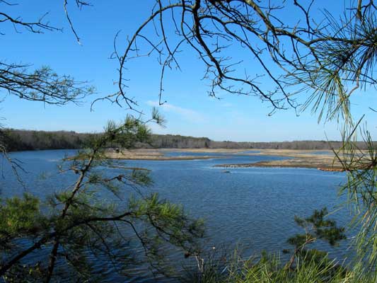
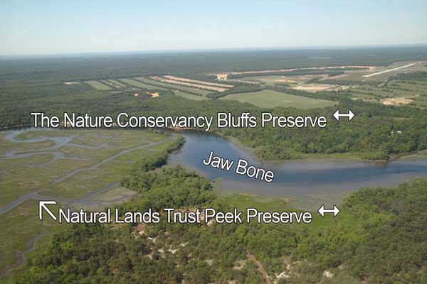
The Peek family home was just a long stroll from the river's edge, where they lived from 1957 until 1992. Today this property is the Harold N. Peek Preserve, a 252-acre property protected by the Natural Lands Trust. Trails take visitors through hardwood and white cedar swamps, across a sandy tract where pines and a prehistoric evergreen groundcover grows, and to the top of the bluffs that rim this eastern bank of the Maurice River. An overlook gives a good view of a wild rice marsh.
Opposite the preserve, on the western shore of the Maurice River, are other tracts of land that are being established as public use lands. The names associated with this location changed as the tides of industry ebbed and flowed.
At one time the area was known as "Coal Wharf", where a loading dock provided a landing for commercial activity. On an 1876 survey map compiled by the NJ Riparian Commission, there is a wharf indicated on this reach.
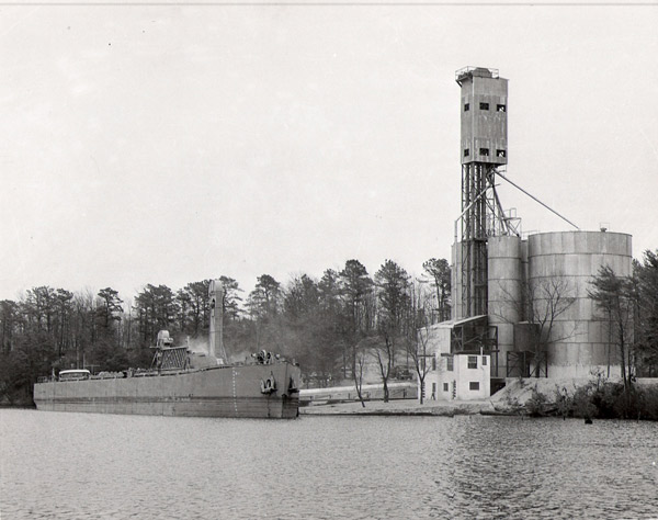
Another area resident, Richard Weatherby recalled that in the 1950's, when he was 6 or 7, a barge ran into and demolished one of the wharves at this reach. This may have been the end of an old era. In 1974, the Cargill Corporation, a global supplier of food, agricultural and risk management products and services, anchoreda new facility on the banks of the Maurice River. The reach became known as the Cargill Granary.
In 2005, Cargill's director of corporate archives Bruce H. Bruemmer provided the only records he found about the corporation's operation in Millville. Mr. Bruemmer wrote:
From an employee newsletter, I have the following on the Millville
facility. Cargill had proposed construction by 1952. In 1953 it was under
construction, and operational by January 7, 1954. Elwood Wink was in charge of merchandising, and Jerry Erlandson was the Elevator Superintendent. Chet Cook replaced Wink in 1954, and Ed Winter replaced Erlandson in 1957. A 1958 newsletter announced that the elevator was closed until further notice on Dec 19.
A bid for the construction of the elevator indicates the following facility: 115,000 bushel elevator utilizing 2 steel tanks, 38' 7-5/8" x 48', and three steel tanks 12' 3" x 56'. I do not know if this was the final configuration; it was the final capacity of the elevator.
A letter to Mr. Edwin Gerber of the Southern New Jersey Development Council from John MacMillan, Jr. (head of Cargill) noted that Cargill had acquired the site "on the Maurice River just below Millville and hope before long to begin construction of a grain elevator." He added that the dimensions of the barges that Cargill planned to use on the river were 241 ft. long x 35 ft. beam by 12 ft. draft.
The May 1954 issue of Cargill News had a small piece on the elevator. It said, "This is the first official picture of the newest eastern installation of Cargill at Millville, New Jersey. The elevator has a capacity of 115,000 bushels and is located on the Maurice River. Tied up at her loading leg is the Cargo Carriers vessel Carpeake. It looks as though Millville, New Jersey is really in business now with the arrival in March of the Carpeake carrying 48,000 bushels of wheat. Cargill is believed to have made history in Millville, as the 303 foot barge is known to be the first of its kind and the largest vessel ever to come up the mouth of the Maurice River."
Cumberland County historian Robert Francois remembers watching the operations at the Cargill Granary. The wharf was very active with barges coming in to be loaded, he said. There was a series of conveyor belts, the cargo cars holding bins, and the grain elevator. He also remembered that despite the commercial activity, the Millville's Sea Scouts (a component of Boys Scouts of America) would often stop at the artesian well at this reach to take on its fresh, "sweet" water.
The Burcham twins, Janice and Janet, also remembered watching the huge boats going up and down the river. They inherited the Burcham property after their parents passed on. They became acutely aware of the activities on the river and how the river traffic impacted the diked perimeter of their farm. They recalled that boats that carried the grain to Cargill's would have a hard time getting around their dike. "The river was too narrow for the grain boats," Jeanette said.
Local resident Everett Turner said he often watched the "enormous barges" traveling the river.
A news clipping from 1971 gives a glimpse at the fate of the Cargill Granary: "Today, Maurice River is still a navigable river but not for modern freight carrying vessels. An experiment to handle grain shipments was tried a few years ago when a wharf was built about a mile and a half south of the bridge with a large warehouse being erected on the west shore. The enormous barges experienced great difficulty getting up the river and turning around. The effort was abandoned after several months of trial."
After Cargill abandoned the facility, it became an interesting destination for local residents and "explorers." Everett Turner is one local who will confess to climbing the grain elevator. "I climbed that many times, after it was abandoned," Turned admitted sheepishly.
 Renowned regional artist Pat Witt said she obtained permission to bring her artist friends up to the old granary site to paint. In the late 1960's and early 1970's, she and students from the Pennsylvania Academy of Fine Arts would travel to the untamed landscape. Some of them even stayed and camped on the bluff above the river. Witt had fond memories of the time and the place. She offered imaginative ideas artists shared about the location. "We were going to turn it into an art studio. There was an office and a…what do you call that…a hopper?" She laughed. "I was going to make art schools everywhere," Witt said, adding that the view from the old Cargill Granary was another of her favorite vistas of the Maurice River.
In 2005, there are still echoes of the last commercial enterprise on the site. Up on The Bluffs, the foundations of the grain elevator provide a peak into the past. The bridge to the future lies in the on-going efforts to preserve the natural beauty that has almost erased the commercial ties to the land. In 2004 the Nature Conservancy purchased a large stretch of land linking and preserving nearly two miles of waterfront including this reach.
 click to navigate the map "up".
 click to navigate the map "down".
 click to navigate the map "left".
 click to navigate the map "right".
 click to "zoom in" for a closer look.
 click to "zoom out" to back away from the map.
 click to get back to the "default" map setting.
 click to learn more about that reach.
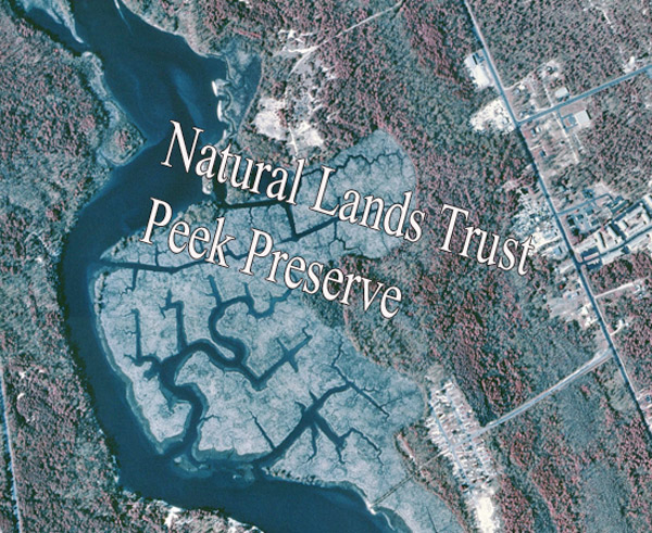